What is PAGeNet?
The Philippine Active Geodetic Network (PAGeNet)
is a network of permanently-installed, continuously operating geodetic reference
stations that utilizes signals from Global Navigation Satellite Systems (GNSS) to
provide real-time, high-precision geographic position data to users via the Internet.
Data from the network may be used in a wide array of applications such as surveying,
mapping, navigation, crustal deformation studies, and meteorology. The PAGeNet is
an important component of NAMRIA’s strategic plan to modernize the Philippine Geodetic
Reference System (PGRS) by year 2020. It provides a continuous link to the International
Terrestrial Reference Frame (ITRF) and is one of the Agency’s contributions to the
development of a sustainable global geodetic reference frame as called for by the
United Nations General Assembly through Resolution No. 69/266 of 26 February 2015
(A Global Geodetic Reference Frame for Sustainable Development). Established in
2008, the PAGeNet currently comprises of 61 active geodetic stations installed nationwide.
Three of its stations (PTAG, PPPC, PGEN) are already incorporated in the International
GNSS Service (IGS) Tracking Network.
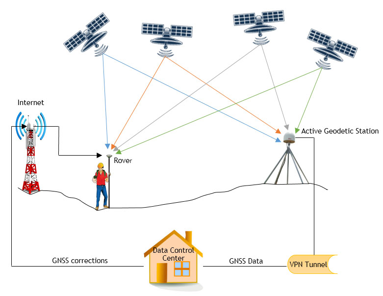
Active Geodetic Station
The AGS are permanent GNSS stations
of the PAGeNet that receive satellite signals twenty-four (24) hours a day for precise
determination of geographic position (latitude, longitude and height). All sites
are selected based on the required and desired site characteristics recommended
by the IGS for permanent reference stations. The stations are equipped with geodetic-grade
GNSS receiver and antenna to ensure quality GNSS data. Supplementary sensors such
as meteorological and tilt sensors that gather temperature, humidity, pressure and
pillar deflection data are also installed in selected sites. The AGS are connected
to the DCC via a Virtual Private Network (VPN) using wired or wireless internet
connection. Most of the stations utilizes solar power to operate.
Ground-Based Station
Roof-Based Station
Data and Control Center
Data from the remote sites are sent to
the DCC which serves as the Information Communication Technology (ICT) facility
of the PAGeNet. Network monitoring, online processing, as well as storage and distribution
of geographic data are being carried out in the DCC which is manned by a pool of
technical staff. The DCC is equipped with high-end data processing and storage resources
to efficiently monitor and manage the data generated by the PAGeNet.
How PAGeNet Works
Through the years, GNSS has established its
niche in the surveying and mapping industry with its cost-efficient, reliable, and
precise means of position determination. Autonomous positioning with GNSS (i.e.
one GNSS receiver and four or more satellites in view) usually yields a position
within +/- 3 to 10 meters. For applications that require higher precision, relative
positioning is usually used wherein data from a base station (with precisely known
coordinates) are used to correct the GNSS data gathered from a rover receiver. This
technique works by reducing/eliminating distance dependent errors common to both
base and rover receivers thus yielding better positioning results. Traditionally,
these base stations are temporary installations, only set up based on the needs
of a project. The proliferation of permanently-installed continuously operating
reference stations, such as the PAGeNet’s AGS, provides a viable alternative by
eliminating the need to set up a separate base station. This, in turn, ensures efficient
utilization of resources and improves productivity while maintaining consistency
of positioning throughout the coverage area. PAGeNet data may be sent in
post-processed or real time mode. For post-processing, RINEX files of the AGS are
available for download at different logging intervals and file lengths. Real time
corrections, meanwhile, are sent through RTCM messages using the NTRIP. RTCM – Radio
Technical Commission for Maritime Services NTRIP – Networked Transport of RTCM via
Internet Protocol